With the foregoing modifications to the recommendations of the Commission the plans upon which this estimate is made are described as follows:
SCHEME I
Scheme I, or as it has been designated, the "Canal St. Belt Line,"
is a two-track railway throughout its length.
The location and types of construction, are as follows: Beginning at the intersection of the Canal and Vine Streets the railway, in a subway, follows the Canal to a point about 1000ft. north of Ludlow Ave., with the exception of three short sections where, because of the sharp bends in the Canal, the line is deflected to the west and runs, in the open, over private lands. The first deflection is between Straight St. and Marshall St.; the second is north of Bates Ave. across from the lands owned mostly by the City and used as the City Workhouse* farms; the third is just south of Ludlow Ave. From the end of the subway section to Mitchell Ave. the tracks are generally in the open following, as nearly as practicable, the west or north bank of the Canal leaving the other side for the Boulevard. Near Clifton Ave. the line crosses the Canal right-of-way fourtimes [sic] becoming a covered subway at each of these places to permit the Boulevard to pass over it.
From Mitchell Ave. to St. Bernard the line follows the Canal right-of-way, in the open. At St. Bernard a sharp bend in the Canal again makes necessary a deflection to the west and the railway passes under Carthage Ave. [Vine St.] and private property in a subway, to a point a short distance north of Ross Ave. Here the line leaves the Canal and turns eastward, in the open, passing over private property to Broerman Ave. near the Jarecki Chemical Company's works. Between Broerman and Imwalle Avenues the subway type of construction is used again.
From Imwalle Ave. the line runs eastward, in the open, crossing over Ross Ave. about 500ft. to the east of St. Mary's Cemetery, over Paddock Rd. about 160ft. south of Ross Ave., under the N.&W. R. R., over Reading Rd. and continues along the hillside south of Ross Run to the B.&O. S-W R. R., at Section Ave., Norwood. Between St. Bernard and Norwood the railway is on private property located far enough south of the B.&O. S-W R. R. to avoid obstructing possible industrial developments along the steamroad and also to permit future streets to be laid out passing, with easy grades, either over or under the B.&O. S-W R. R. At Section Ave. the line crosses under the B.&O. S-W R. R. and continues easterly mostly as a subway along the railroad right-of-way, Harris Ave. and other private property to near Beech St. Here it turns southward, again crossing under the B.&O. S-W R.R., and continues along Beech St., in the open, except at street crossings, to Duck Creek Rd. Crossing over Duck Creek Rd. it turns southwest, passes, in a subway, under Edmonson Rd. and continues in the open on the east side of Duck Creek, crossing under the N.&W. R. R. and over Vista Ave. to a ravine a short distance south of Vista Ave. In this ravine the line turns southward and runs, in the open, to Owls Nest Park where it changes to a subway and, as such, crosses under the Park and Madison Rd. to the west side of Torrence ravine. Continuing southward in the open for a short distance, the line then turns southwestward and, by tunnel, passes through the point of the hill emerging south of Keys Crescent and then continuing in the open along the side of the hill crosses over Humbolt Ave. a short distance east of McMillan St. and continues to the Ohio River Bluff above Columbia Ave. From here the line runs westerly in the open, along the bluff above Colubmia Ave., crossing over Kemper Lane, to near the Eden Park Reservoir. Here it turns westward and, by tunnel, passes under Mt. Adams and, in a subway, under Gilbert Ave., the C. L. & N. R. R., private property and Canal St. to the place of beginning at Vine St.
The total length of the line is 15.56 miles, of which 6.50 miles are in subway, 0.63 miles in tunnels and 8.43 miles in the open. Included in the open are twenty bridges with a total length of 2,206ft. and 6,100ft. concrete trestle along the Ohio River Bluff.
The reasons for adopting a concrete trestle type of construction along the river bluff are as follows:
The earth formation in this vicinity is made up of horizontal strata of lime stone from one to eight inches in thickness, separated by strata of shale from two inches to three feet in thickness. The shale, when exposed to air, disintegrates and makes a clay. The disintegration of the shale and the general downward sliding movement of the earthy material along the whole bluff have, in the course of time, covered the entire hillside to various depths with a clayey earth in which are imbedded fragments of limestone. In various places water, following along some of the limestone strata, appears on the surface making a plastic material of the clayey earth.
There is probably some downward movement of this loose earth covering along the whole bluff, but the movement is very noticeable where the ground is wet. The whole bluff appears to be in a state of uncertain equilibrium and any disturbance of the loose earth tends to cause the whole hillside to moved downward till a new equilibrium is obtained.
The unreliability of making embankments on this hillside is illustrated by the sliding in many places of Columbia Ave., where it is, in part, made by an earth embankment. The result of excavating trenches or benches along the hillside is illustrated by the sliding of the earth over a considerable area where retaining walls are built at the grade crossing elimination work no in progress on Eastern Ave., east of Kemper Lane.
The problem is to devise a method of supporting the tracks that will be permanent and disturb the surface as little as possible. Piles can not be used as they could not be driven into the shales and limestone. The plan adopted is to construct concrete piers about 30ft. apart with their foundations sunk and keyed into the undisturbed material. These piers are to be connected by reinforced concrete beams on which is laid a reinforced concrete floor and the track will be laid in ballast on this concrete floor. The grade of the track is such that the ground is not disturbed between the piers. The width of the trenches is which the piers are built is about one-tenth of the span between the piers. The concrete piers will act as an anchor holding back and tending to prevent a downward movement of the earth.
The grades of the proposed boulevard have not been officially
determined,
but grades have been assumed in making these estimates and unless these
assumed grades are approximately followed, it will have some effect
upon
the estimates hereto attached. The cost of paving and grading of
streets, that cross or end at the Canal, to make them conform to the
Boulevard
grade has not been included in the estimates. The removal of all
the bridges, no crossing the Canal, is contemplated, with the exception
of four; viz.: -- those at Brighton**, Marshall
Ave., Hopple St. and Ross Ave. These should be left in the
present
location, the elevation only being subject to change.
*The subway would have emerged in
front of the
old Camp Washington Workhouse, which was demolished around 1990.
**The Brighton Bridge was rebuilt in 1928, and
is still in use. The three others were dismantled.
STATIONS
Stations are to be built with 240ft. platforms, with provisions for extension to 400ft.
There are 14 stations in Scheme I, spaced about one mile apart and located as follows:
CANAL STATION is in Canal St. between Vine and Race Streets, with exits and entrances at both of these streets. This station is made larger than the others because it will be the terminus for baggage and light express articles handled by the several interurban lines. Switches are here provided that will permit the interurban cars to make their return trip.
LIBERTY STATION, 0.68 miles from Canal Station, is in the Canal right-of-way with entrances and exits at Liberty St.
BRIGHTON STATION, 1.68 miles from Canal Station, is in the Canal right-of-way. The exact position of this station is fixed by two curves in the track alignment that will just permit the station being located between them. Because of the narrow right-of-way in this place, part of the station will be under the walls of the bridge approach. Connection with the surface is obtained by a ramp and a short stairway station at the intersection of the Brighton Bridge approach and Colerain Ave. The two platforms of the station are connected by a passageway under the tracks.
HOPPLE STATION, 2.76 miles from Canal Station, is located in the Canal right-of-way at Hopple St. with entrances and exits at Hopple St. The choice of this location for a station was largely due to the Hopple St. Viaduct now under construction over Mill Creek Bottoms.
LUDLOW STATION, 3.90 miles from Canal Station, is located on private land land south of Ludlow Ave. with entrances and exits at Ludlow Ave. This is the first station in the open.
CRAWFORD STATION, 4.68 miles from Canal Station, is located along the west side of the Canal opposite the end of Crawford Ave. A passageway under the tracks permits access to both platforms from either side of the tracks. The principal reason for a station at this place is that Crawford Ave. is the terminus of the Ohio Electric Railway. [College Hill Interurban]
MITCHELL STATION, 5.74 miles from Canal Station, is an elevated structure, over Mitchell Ave., located on private land to the west of the Canal with entrance and exit at Mitchell Ave.
ST. BERNARD STATION, 6.56 miles from Canal Station, is in a subway, on private land to the west of the Canal between Carthage Ave. [Vine St.] and Ross Ave. with entrances and exits at Carthage Ave.
PADDACK [sic] STATION is 7.70 miles going west from Canal Station and 7.86 miles going east from Canal Station. It is an elevated structure on private land to the east of Paddack Rd. with exit and entrance at Paddack Rd.
MONTGOMERY STATION, 8.94 miles going east from Canal Station and 6.62 miles going east from Canal Station, is in the open and on private land to the north of the B.&O. S-W R. R. and west of Montgomery Ave. with entrance and exit at Montgomery Ave. With little additional expense a passageway can be constructed under the tracks of the B.&O. S-W R. R. to this station from the steam railroad station.
FOREST STATION, 6.06 miles going east from Canal Station is on private lands south of Harris Ave. and east of Forest Ave. It is partly in the open and partly under cover, with entrance and exit at Forest Ave.
OAKLEY STATION, 5.21 miles going east from Canal Station, is in a subway on private land on the east side of Duck Creek opposite Smith Rd.* Entrances and exits are at Dacey Ave.
DANA STATION, 4.50 miles going east from Canal Station, is in the open on private land to the east of Duck Creek and between the N.&W. R. R. and Vista Ave. The City has considered the building of a viaduct over Duck Creek Valley on the line of Dana Ave. Should this viaduct be built this station could, without making alteration, be connected with it.
MADISON STATION, 3.39 miles going east from Canal Station, is on private land to the south of Madison Rd. It is partly covered and partly in the open, with entrances and exits at Madison Rd.
*The "Oakley Station" was in the vicinity of today's I-71 Smith-Edwards interchange. The loop was to run along the exact path of I-71 between this interchange and the Dana Ave. interchange.
SCHEME II
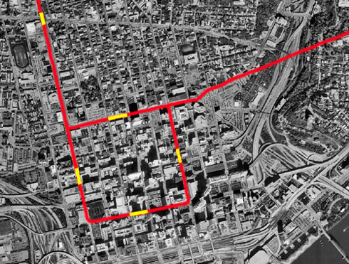
Subway in RED, stations
in YELLOW
Scheme II supplements Scheme I and is a loop line that encloses a large part of the downtown district of the City. It leaves the "Canal St. Belt Line" at the intersection of Canal and Plum St. and runs south in Plum St. to 5th St., east in 5th St. to Main St., and north in Main St. connecting with the Belt Line in Canal St. This loop is a two-track subway throughout, 1.31 miles in length, making with the Belt Line a total of 16.87 miles. There are three station located upon it. One in Plum St. with entrances and exits at both 7th and 8th streets. One in Fountain Square with entrances and exits at both Vine and Walnut Streets, and one in Main St. with entrances and exits at both 7th and 8th streets. These entrances and exits are all from the sidewalks.
The cost of the Loop Railway per lineal foot is considerably more than the cost of the Subway in the Canal, largely due to the presence in the streets of sewers, electric ducts, water and gas pipes which will have to be supported during the construction of the subway, or removed to a new location, the extra precautions required because of the nearness of large buildings, the removing and restoring of the pavements and the delays in construction due to business and traffic in the streets.
It is assumed the work will be done in an open trench not more than 400ft. of continuous street, including only one cross street, being open at one time.
Scheme I and Scheme II supplement each other and together make an
ideal
transit plan. Scheme I or the "Canal Street Belt Line" surrounds
a residential district. Scheme II or the "Loop Line" encloses a
large
part of the business district, the prosperity and permanence of which
largely
depends upon the conveying of the residents of the City to and from
their
business houses in the shortest time and with the least inconvenience."
SCHEME III
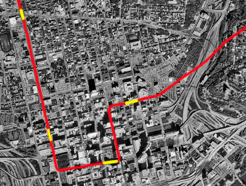
Subway in RED, stations
in YELLOW
Scheme III or the "Ninth St. Belt Line" includes Scheme I with the exception of that part east of Plum St. in Canal St. and under Mt. Adams to near the Eden Park Reservoir. For the part omitted, the following route has be substituted: from the intersection of Plum and Canal Streets south in Plum St. to 5th St., east in 5th St. to Walnut St., north in Walnut St. to 8th St., east in 9th St. and under Mt. Adams to connect with Scheme I near the Eden Park Reservoir.
The substituted part is a two-track subway or tunnel throughout. The total length of the scheme is 16.31 miles, which includes 7.07 miles of subway, 0.80 miles of tunnel and 8.44 miles in the open. Canal Station is omitted and three stations added as follows: one in Plum St. with entrances and exits at both 7th and 8th Streets, one on Fountain Square with entrances and exits at both Vine and Walnut Streets, and one in 9th St. with entrances and exits at both Main and Sycamore Streets. In this scheme it is assumed that all interurban baggage and express matter will be handled at the Plum St. Station.
The object of this scheme is to reduce the cost of the combined
Schemes
I and II and retain the advantages of the stations in the business
district.
A subway and station in Canal St. may be added at any time traffic
conditions
require it.
SCHEME IV
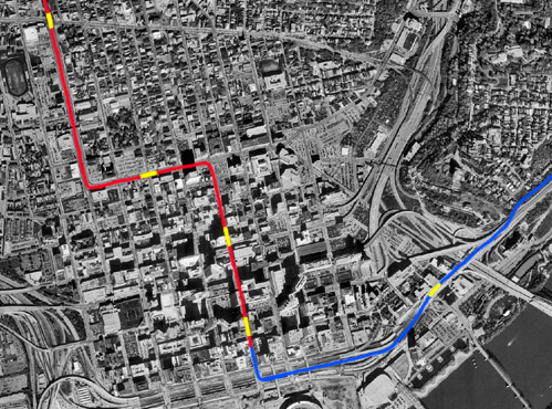
Subway in RED, elevated
in BLUE, stations in YELLOW
Scheme IV, or the "Pearl St. Belt Line," includes Scheme I with the exception of that part east of Walnut St. in Canal St. and under Mt. Adams to near the Eden Park Reservoir. For the part omitted the following route has been substituted: from the intersection of Canal and Walnut Streets south in Walnut St. to Pearl St., then east in Pearl and Martin Streets and private property to connect with Scheme I near the Eden Park Reservoir.
The substituted part is a two-track subway in Walnut St. from Canal St. to 4th St. Between 4th and 3rd Streets, the tracks, on a rising grade, break through the ground and continue on a rising grade till they are on a steel elevated structure on 3rd St. The elevated structure is continued in Pearl and Martin Streets and over private property to connect with Scheme I near the Eden Park Reservoir. The total length of the scheme is 16.46 miles, which includes 6.40 miles of subway, 0.15 miles of tunnel, 1.44 miles of elevated structure and 8.47 miles in the open. The location of Canal Station is changed from between Vine and Race Streets to between Race and Elm Streets and three stations are added, one on Walnut St. with entrances and exits at both 8th and 9th Streets, one on Walnut St. with entrances at both Fountain Square and near 4th St., and one on Pearl St. at the approach to the L&N Bridge with entrances and exits at the Pennsylvania Railroad Station.
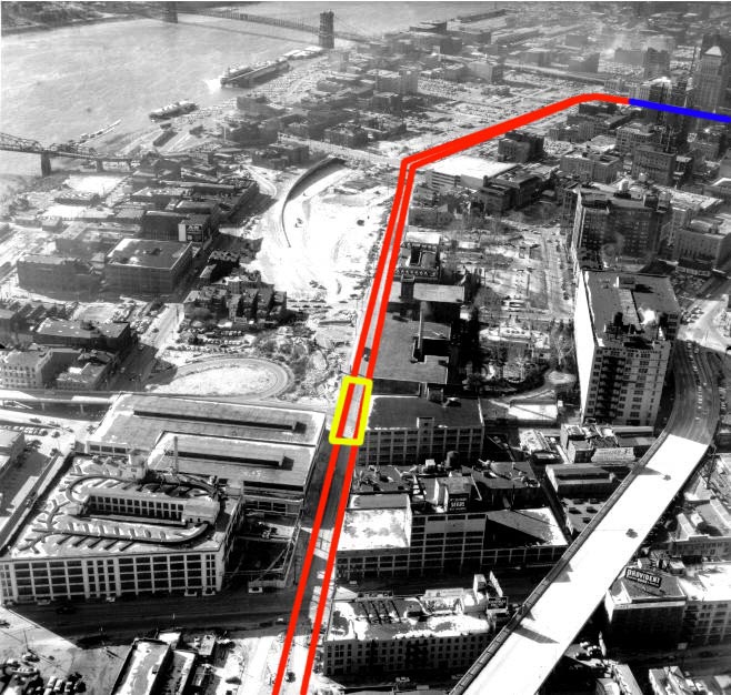
This unofficial graphic illustrates the route of the proposed Pearl
St. Viaduct in red and
Walnut St. subway in blue over a 1950's shot of the riverfront.
By use of an elevated structure in the substituted route in the place of a subway or tunnel, the cost of construction is considerably reduced. Although nine-tenths of a mile longer than Scheme I, the cost is about the same.*
In the downtown district the number and locations of the stations is Scheme IV offer almost as many advantages to those who would make use of the railway as do the combined stations of Schemes I and II and at a much less total cost. If at some future time, it were deemed necessary to place the tracks of the Kentucky surface lines that are in this City in a subway, the connection with the Cincinnati Rapid Transit Railway could not be so advantageously made under the plans of Scheme IV as under the plans of Schemes II and III.
Changing from a subway to an elevated structure on Walnut St. between 4th and 3rd Streets, makes it necessary to occupy a strip of the street 25ft. in width for practically the entire distance between those two streets. There will remain 20.5ft. on each side for street purposes. Allowing 8ft. for a sidewalk and 1ft. as a hubguard to protect the fence along the open incline track, there will remain 11.5ft. clear space for roadway which will make necessary a one-way street.
*Elsewhere in the web page the Pearl St. el is called the "3rd St. el", because neither Pearl St. or Martin St. still exist. Pearl St. paralleled 3rd St. where the mainline trench of Fort Washington Way is today, and the el would have roughly followed the route of the U.S. 50 3rd St. Viaduct to Mt. Adams.