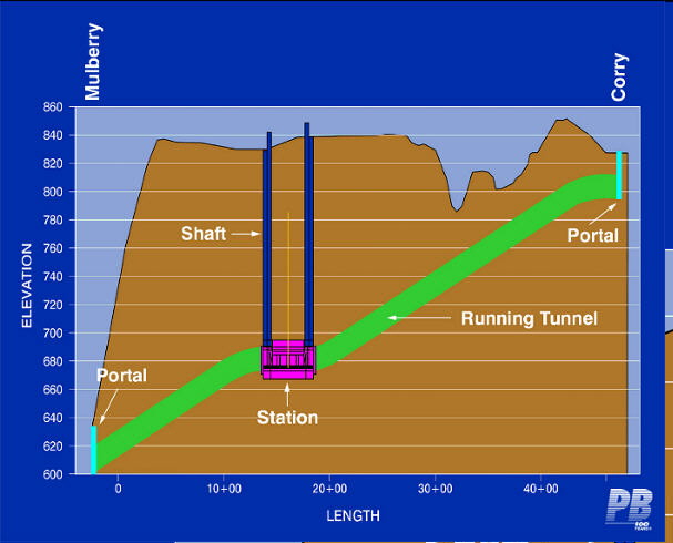
Mt. Auburn Light Rail Tunnel
In June of 2002, in
anticipation of the November "Metro Moves" campaign, the light rail
alignment that would have required the Mt. Auburn Tunnel was abandoned
in favor of a cheaper route which would have followed I-71 out of
dowtown, bypassing the University of Cininnati area.
The
Cincinnati Business Courier
did the best reporting on the light rail proposal, but unfortunately
asked me to remove their articles from the site. Registration is
free, and they can be seen at http://www.bizjournals.com/cincinnati
in the archives section. Simply type "light rail" for over a
dozen articles. The Cincinnati
Enquirer and Cincinnati Post
archives are not free.
Mt. Auburn Light Rail Tunnel
The Mt. Auburn Tunnel was part of a proposed 30+
mile light
rail line running from the Cincinnati/Northern Kentucky Airport
in Hebron, KY north to
King's Island Amusement Park in Mason. The initial line was to have run
from 12th St. in Covington to downtown Cincinnati, The University of
Cincinnati, and terminate at Xavier University. This segment
would have included a new bridge over the Ohio River (likely adjacent
to the Clay Wade Bailey Bridge) and a major tunnel under Mt. Auburn.
The Mt. Auburn Tunnel was planned to eventually
carry traffic
from three different light rail branches, which would have converged
about four
miles north of the tunnel adjacent to Xavier University's campus.
An eastern branch along the
presently existing Wasson Rd. freight line through Hyde Park and a
longer
northern branch roughly paralleling I-75, possibly as far north as
Hamilton,
could eventually bring a tremendous volume of traffic to the tunnel,
thereby
justifying its high cost.
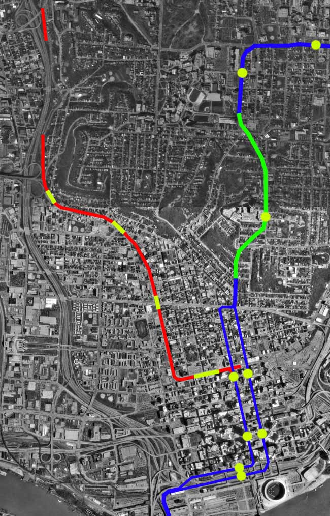
Possible integration of existing subway
tunnel with proposed
light rail line is obvious from this diagram. Existing subway is
constructed
just below street level, so ramps leading to the surface would be
easily
constructed.
RED
SHOWS
EXISTING SUBWAY TUNNEL
*modern rolling stock can
use the
existing tunnels.
BLUE
SHOWS SURFACE RUNNING PORTIONS OF
PROPOSED LIGHT RAIL
LINE
*Light Rail line is
currently planned
to run split between Main St. and Walnut St. and on either side of Ft.
Washington Way.
YELLOW
SHOWS
STATION LOCATIONS
*Light Rail Stations, from
top
to bottom: University Hospital, University of Cincinnati, Christ
Hospital (Auburn Ave.), Court St., 5th St., Riverfront
GREEN
SHOWS
MT. AUBURN TUNNEL
*Tunnel to be dug several
hundred
feet under the hill.
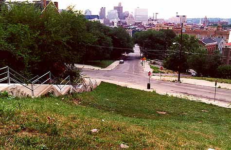
Standing at the south portal location, above Mulburry
St., looking south towards downtown.